GEOSPATIAL ENGINEER SKILLS, EXPERIENCE, AND JOB REQUIREMENTS
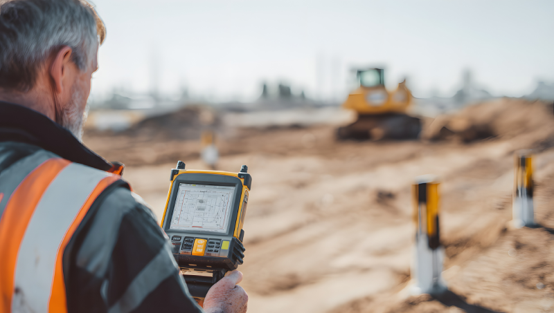
Updated: Jun 22, 2026 - The Geospatial Engineer proficient in CAD software (LSS/Autodesk Civil 3D/Trimble Business Centre) and capable of generating 3D models using Autodesk/Trimble software. This position requires experience in GIS data manipulation and analysis, with expertise in volumetric analysis and earthwork processes. This role requires excellent problem-solving abilities, strong communication skills, and the ability to manage the Digital Bid process and meet deadlines while adapting to new challenges.
Essential Hard and Soft Skills for a Standout Geospatial Engineer Resume
- Cloud Automation
- CICD Patterns
- Object-Oriented Programming
- Configuration Management
- Terraform Artifacts
- Kubernetes Artifacts
- Observability Integration
- Mapping Pipeline
- System Design
- Geospatial Data
- Customer Analysis
- Business Collaboration
- Presentation Creation
- Proposal Development
- Research Development
- Project Planning
- Geospatial Modeling
- Secure Application
- API Integration
- Server Configuration

Summary of Geospatial Engineer Knowledge and Qualifications on Resume
1. BS in Geospatial Engineering with 4 years of Experience
- Knowledge and experience with Geographic Information Systems (GIS) technologies and software packages and tools.
- Experience developing in data languages for Earth science data, including Python
- Proficiency working in a UNIX/Linux command-line environment and shell scripting
- Experience with reading, subsetting, interpreting, and utilizing geospatially referenced and structured data for research and applications.
- Familiarity with the git source code management system
- Strong analytical, problem-solving, organizational, and written/oral communication skills.
- Ability to meet deadlines and possess the ability to work independently.
- Able to multitask and demonstrate the ability to work with a diverse work group of vendors, executive managers, subcontractors, consultants, and other professionals.
- Able to communicate effectively with company executives and employees, in writing and verbally
- Ability to formulate accurate and useful problem statements in collaboration with other researchers
2. BS in Geography with 2 years of Experience
- Able to produce and manipulate 2D drawings
- Proficient in the use of CAD software i.e. LSS\/Autodesk Civil 3D\/ Trimble Business Centre
- Able to generate 3D Models (Autodesk\/Trimble Software)
- Proficient in the use of Microsoft Excel software (pivot tables, lookups and other advanced data manipulation tools).
- Experience in carrying out volumetric analysis and understanding earthwork processes
- Excellent problem-solving skills, with willingness to take responsibility for the \u2018Digital Bid process'3D Modelling (Scan to BIM)\/ Verification.
- Experience in GIS data manipulation\/analysis\/reporting
- Understand and apply meaningful metrics to measure results, to adapt and learn new things to execute specific research projects, and to meet task deadlines and goals.
- Excellent communication skills, be intrinsically motivated, dependable, responsive, curious, collaborative, and have excellent interpersonal skills.
3. BS in Environmental Science with 3 years of Experience
- Experience designing, implementing, and/or administering enterprise GIS solutions/systems that leverage the ArcGIS platform (desktop, server, and online)
- Experience with Esri software including ArcGIS Enterprise, Portal for ArcGIS, ArcGIS Pro, ArcGIS Online, and associated APIs or interfaces
- Experience in Python scripting, including the ArcGIS API for Python and arcpy
- Knowledge of geospatial and mapping concepts such as spatial analysis, map projections, etc.
- Excellence in technical consulting, solution design, project envisioning, planning, developing, and deployment
- Knowledge of Agile software development methodologies (e.g. Scrum)
- Strong, persuasive communication skills
- Ability to clearly communicate technical ideas, whether to other technical peers or non-technical project managers or customers
- Experience with ArcGIS Velocity, ArcGIS GeoEvent Server, or other low-code integration platforms
- Experience scripting with geospatial and data science-centric Python libraries (arcpy, python API, pandas)
Editorial Process and Content Quality
This content is developed by the Lamwork Editorial Team using structured analysis of real-world job data, skill requirements, and hiring patterns.
Research framework by Lam Nguyen, Founder & Editorial Lead.
Reviewed by Thanh Huyen, Managing Editor.
Learn more about our editorial standards.